

A Journey to the Center of La Réunion: Mafate
A Journey to the Center of La Réunion: Mafate
Hiking the GRR2 across the Island

Author’s Note: This piece first appeared on Concordia Language Village’s Worldview Blog. It was written in Fall 2018 while I was living on Réunion Island. You can find that article here: http://www.concordialanguagevillages.org/blog/ventfrais/a-journey-to-the-center-of-la-reunion-mafate
For the past 4 weeks, I’ve been living on a small rock in the Indian Ocean, called Reunion Island. I say this because the locals like to call it un petit caillou dans l’océan Indien, which means exactly that. I’ve just started work as an English teacher here in this French overseas department, and I’ve learned very quickly that people here are proud of their small isolated island, its unique food, and its stunning scenery. On an island where more than 80% of the population lives within 30 minutes of the coast, I had an incredible opportunity to visit the less-developed interior of the island: Mafate. Here there are small towns, but no cars, no roads, and very limited services. Everyone has to get around by foot or by horseback, and foods and goods are helicoptered in on a daily basis. Here is the story of my adventure into the center of La Réunion.1
A Note on Scale
Let’s begin with a little context: to give you a rough estimate, La Réunion is pretty small compared to most everything in the United States. For example, the entirety of La Réunion can fit inside the state of Minnesota … 90 times!

That’s pretty incredible, but La Réunion is wildly different from Minnesota in many other ways as well. For one, it’s mountainous, with its highest point reaching above the clouds at 3,070 meters (10,069 ft.) That point is called Le Piton des Neiges, and it’s a point that I visited on my adventure through Mafate. La Réunion also has a much warmer climate in general, in fact it only snows approximately once every 10 years, at Le Piton des Neiges!
I trekked into Mafate with two other American teachers on the island, working in the same program as I am. The trail we decided to follow was called the GRR2, also colloquially known as La Diagonale Des Fous (The Lunatic’s Diagonal) because it cuts a nice diagonal across the entire island, beginning in St. Denis and ending in St. Philippe. The whole trail takes approximately twelve days, and is approximately 160km. My group wanted something a bit shorter, so we decided to do the trail up until La Plaine des Cafres, and then exit from there, comprising about 70% of the trail. Below is a map of the GRR2 in blue, and our route deviations in orange.

A rough view of our itinerary (begin/end points in red). An interactive version of this map can be found here.
Setting Off - La Grande Montée
There are many different sub-climates in La Réunion, and we experienced a large variety of them over the course of this trek. Two general rules apply: the farther inland you are, the rainier it is, and the higher up you are, the more cloudy it is. The two generally coincide.
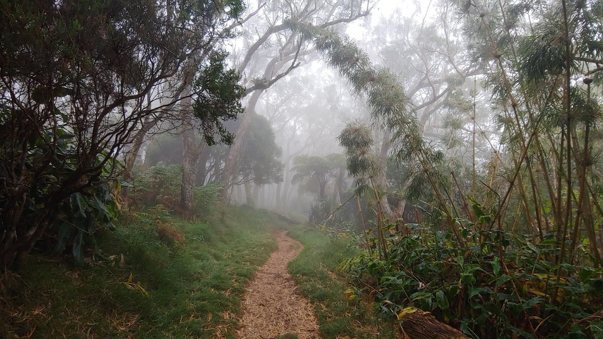
On our first day of hiking, we started off essentially at sea level, and went all the way up to 1850 meters. It was an incredibly strenuous day, but also mesmerizing to watch the weather gradually change around us as we ascended towards La Roche Écrite, our destination for that night.
We departed from St. Denis at around 5h, and our day began extremely arid and sunny, with us struggling to stay cool. By 15h, we were in a lush, misty jungle, with tons of vegetation surrounding us; we were right in the middle of the clouds.


A Day in the Life
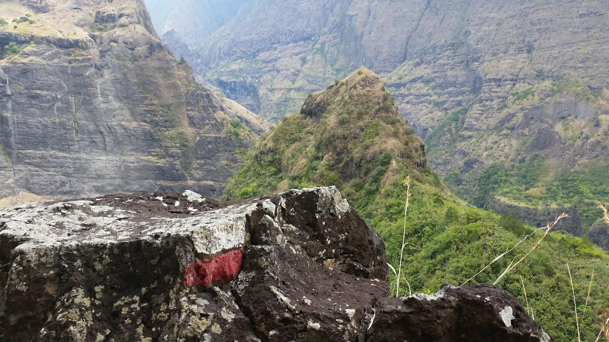
On the third day of our hike, we truly broke into the interior of the island, and arrived in le coeur de Mafate. It was a startlingly different view of the island than what we had been accustomed to seeing—all of a sudden, there was no ocean in sight! We descended into the valley, and were surrounded by mountains on all sides. As we soon would discover to be the new normal, we descended all the way back down to 200m this day. Which of course only served to make the surrounding mountains seem even larger!
As you can see in the adjacent photo, the interior mountains have “fingers” so it is no simple task to get from one ridge to another. Often times we could see our destination across a valley, but we had to descend all the way down (sometimes over 1000m!) to cross a river, only to climb all the way back up on the other side. It was exhausting, but gratifying. This became our daily grind as we travelled from Deux Bras, to Îlet à Malheur, to Grand Place, to Roche Plate, and finally to Marla. A small section of flat terrain was always a respite from the constant uphill and downhill cycle, but those were few and far between.

All along the trail there are gîtes that house travelers for the night. These were small buildings not so different from Les Chalets found on trails in the European alps. The gîtes along the trail are often brightly colored, beautiful structures, where travelers from all over rest their legs and get to know each other. Here you can have a hot meal and shower, and sleep in a bed between long days of hiking. Because we were camping, we didn’t have these creature comforts, but often gîtes would let us camp on their property for free or for a small fee. Camping also made our packs a lot more heavy along the trail, having to carry our shelter and food!

Le Piton des Neiges
The highest peak on the island. This is something that we absolutely had to build into our trip, we all agreed. And to make it even more extreme, the local tradition is to be at the summit for le levé du jour—the sunrise at the top of the world! Which is of course exactly what we did. We woke up at 3h the morning of October 22 and, equipped with our headlamps, went onward and upward under the stars toward Le Piton des Neiges.
After 2 hours of difficult uphill climbing in the dark, we arrived at the summit. The wind was so strong I almost got knocked off my feet several times. It was hard to get a good picture because of the wind and the cold, but it was a surreal experience to see the coastal cities and ocean far below us, and see light gradually spread its way into every pocket of our incredible vista.

That was certainly the pinnacle of the day, because shortly after starting our descent, it clouded over and began to rain. By the time we were back at our gîte, the rain was in full swing, and we still had a full day of hiking awaiting us. As it turned out, the rain had no plans of stopping, so we had our longest, muddiest, slowest-moving day of them all. By day’s end, we had hiked 29km and emerged in La Plaine des Cafres, on the east side of the island. It was our last day of hiking together. We were exhausted, but very content with what we had accomplished.

All Good Things Come to an End
The réunionnais have an expression: battre un carré, which literally means to build a square. Originally, this meant to go for a walk around your cane sugar plantation, so you would effectively be walking in a big square. Nowadays it means to go on a hike or a walk. I can certifiably say that on a très bien battu un carré.
Over the course of 10 days and 9 nights, we hiked approximately 146km, up and down countless valleys and mountain passes totaling more than 8,500m of elevation gain. We were surrounded by amazing forests, and serene, secluded vistas. We got a chance to meet and make friends with many people along the way, speaking French, Créole, English, and German with strangers who became quick trail companions.
This trip was challenging and strenuous at times, but peaceful and breathtaking at others. It was filled with pitfalls and unexpected setbacks, but it also contained some incredible moments of beauty and accomplishment that I will never forget. The landscape surrounding me was totally new to me, the flora and fauna was all foreign, and my days were filled with many cultural interactions, en français!
Because La Réunion is a French department, there are many European influences: the streets are narrow, the shops are compact—as well as the cars, and everybody is walking around with a baguette. If one didn’t see the ocean and palm trees everyday, it could easily be mistaken for a small town in mainland France.
This is what my day-to-day life is like here living near the coast: it’s bustling, fast-paced, and very European. However, this is all in stark contrast to my visit to Mafate. Here in Mafate, surrounded by mountains on all sides, life slows down a lot. I enjoyed that life in the interior is more leisurely; daily life waxes and wanes with the light of the sun. It’s also a lot quieter and calmer without any cars. I am very thankful to have had the opportunity to see this side of the island, and to have had this incredible learning experience; I’m so excited to return very soon!
A Few More Photos


About the Author
"Jean-Canot has been working with CLV's Les Voyageurs since 2011, where he teaches French, camping, and canoeing to young minds in a Northwoods setting. With that experience, Jean-Canot speaks a very Franco-Canadien brand of French. Jean-Canot is currently working in the French overseas department of La Réunion where he lives with a host family and teaches at two schools on the south side of the island. Jean-Canot loves exploring the island by going on hikes, trying new créole cuisine, canyoning, and speaking with locals.”
Originally posted here: http://www.concordialanguagevillages.org/blog/ventfrais/a-journey-to-the-center-of-la-reunion-mafate